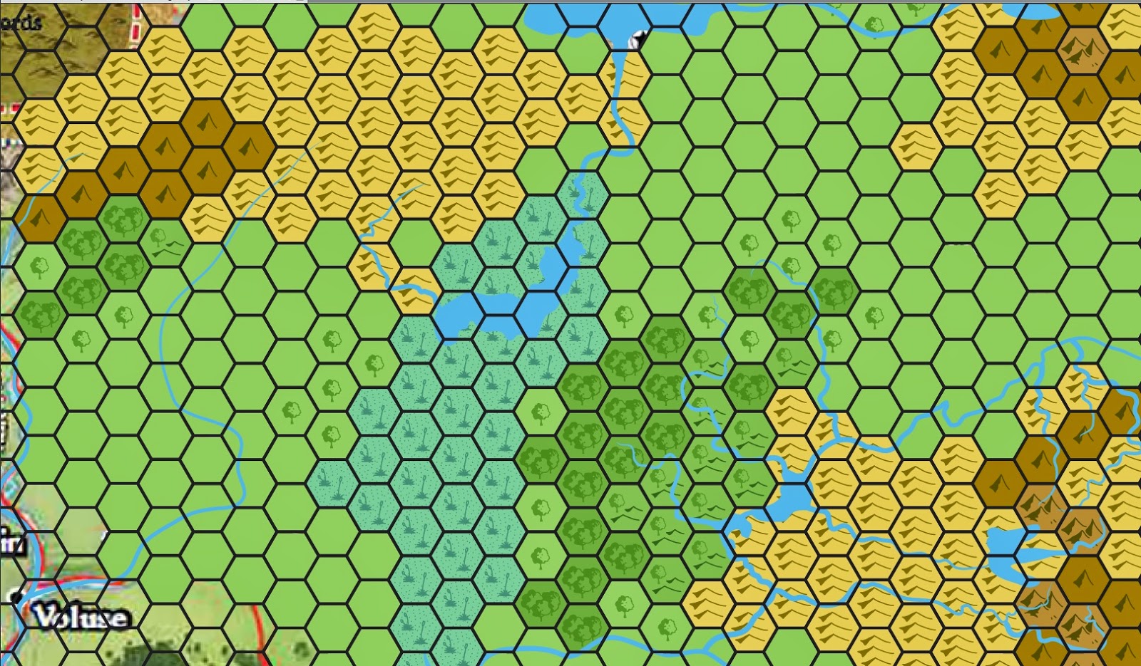
I wanted to toss up a quick version of the Kingmaker AP map that only had the geography. No cities, roads, names, borders, et cetera. Apparently the most frequent request I've gotten is to have a 'clean slate' where a GM can build up everything from scratch. So here it is! Enjoy :)
This is almost the same map as from this post. The only difference is that this map covers slightly more ground to the north and west. This should provide adequate real estate to even have a limited civil war with Brevoy.
Showing posts with label Kingmaker. Show all posts
Wednesday, September 18, 2019
Sunday, February 18, 2018
Map: Pitax, Mivon and the Stolen Lands at 12mi to the hex with some geographic and geologic notes.
![]() |
| Pitax, Mivon and the Stolen Lands at 12 miles to the hex. The full map can be downloaded here. |
It's here! The completed map of Mivon, Pitax and the Stolen Lands at 300 dpi. This should be suitable for using as a background in VTTs like roll20 or as a large handout / foldout for the tabletop.
This map drew on the following sources:
Inner Sea Region Poster Map
PZO9031 - PZO9036: Kingmaker Adventure Path
PZO9217: Pathfinder Chronicles Guide to the River Kingdoms
PZO9226: Pathfinder Campaign Setting: The Inner Sea World Guide
PZO9270: Pathfinder Campaign Setting: Numeria, Land of Fallen Stars
PZO9411: Pathfinder Companion: Gnomes of Golarion
PZO9448: Pathfinder Player Companion: People of the River
Notes:
- Restov is placed where it would be in the Kingmaker AP, approximately 50 miles east of where it would be on the Brevoy map. There is no resolving that corner (where the Stolen Lands, the River Kingdoms, Brevoy and Iobaria meet) so I've worked from the perspective of the most detailed map to the least.
- Mivon is listed as having several settlements between Mivon city and Sarain to the west. These are described as village sized settlements.
- The Branch of the Sellen River bordering Mivon and the Stolen Lands is unnamed. I've attributed the name Mivon Branch of the Sellen to that waterway.
- Mivon's border with the Stolen Lands encroaches on the bottom row of hexes in the Kingmaker AP. However, Mivonese claimed lands do not overlap any of the AP encounter areas. Furthermore, Mivon's ability to enforce their rule north of the Mivon Branch of the Sellen is questionable.
- Brevoy has numerous villages along the East Sellen River and in the vicinity of New Stetven. These are unmarked on the map.
The sediment in the lowlands of the Stolen Lands, Mivon, Pitax and Brevoy is mostly glacial in nature. Glacial sediment is an amalgamation of dirt and stones of all sizes mixed together. It is deposited by retreating and advancing glaciers, in a manner somewhat like a giant bulldozer. Sediment of this kind is most frequently found in the flat, grasslands where the bulldozer effect has smoothed out any previous topography by filling in the valleys and scraping off the ridgetops. Wells driven into this sediment are usually good producers of water, leading to successful farms, even away from rivers. Moreover, glaciers drag rocks from distant places to the Stolen Lands, meaning that there is always some small chance (like 1 in 10,000) of finding some unusual rock randomly. Moreover, the presence of minor ore deposits in the Stolen Lands suggests that there may be more of the same in the Tors of Levenies to the East. Placer hunting for gold in the tributaries of the Gudrin and Little Sellen are certainly possible!
Future Direction:
The next step in this process (barring any revisions to the map brought up by the community) is to have a second map made showing the location of the overland encounters in the Kingmaker AP oriented to the new hex grid.
Following that, I'd like to take a short break and work on a couple dungeon maps (I have a few fun ideas!) that I will then share here.
Following that, it will be time for another hex map. Which begs the question - what part of the Inner Sea would you like to see made into a hex map next? Leave a reply in the comments and I'll do the country that has already been detailed in a Campaign Guide with the most requests.
Friday, February 9, 2018
Harmony - a medium sized town where I once lived.
Harmony is a town created for my GM in our current Pathfinder campaign. It's located in the Stolen Lands, where Kingmaker was and where we have set Strange Aeons. In our campaign universe it's a college town, with the magical academy in the upper right and the Clerical college on the hill to the west. It occupies the space where the "Temple of the Elk" existed in the first AP. Indeed, you can see the leftovers of the temple in the left center at the head of the stream.
Tuesday, August 8, 2017
Trying to get that faded, medieval map look
So I've been asked to make some maps that have that faded, medieval map look that I dearly love. Specifically of the central area in Veridia, our campaign setting in Golarion. This is a completely new experience for me and took a little work to get at least somewhat correct. Here's a couple examples:
This was just a really early map that I tried. I based it of the tutorials I found here, which are awesome. It took some tweaking, but eventually I got something recognizable like this:
This wound up being the basis for the map I'm using. If you're familiar with the Stolen Lands, you will immediately recognize Candlemere Lake and Lake Silverstep. I'll post the finished map when... well, when it's finished! :)
This was just a really early map that I tried. I based it of the tutorials I found here, which are awesome. It took some tweaking, but eventually I got something recognizable like this:
This wound up being the basis for the map I'm using. If you're familiar with the Stolen Lands, you will immediately recognize Candlemere Lake and Lake Silverstep. I'll post the finished map when... well, when it's finished! :)
Saturday, June 17, 2017
Redoing the map for the old AD&D the X1 Adventure: The Isle of Dread
Hi! I'm back after an extended hiatus. Been working on cartoons and other map projects that are all in various stages of completion. But I wanted to share a hex map I put together recently for the pathfinder campaign I'm in.
We wanted to play the old D&D module X1 "The Isle of Dread" but I wasn't particularly pleased with the map (We also swapped out the whole central plateau section for something more appropriate to our campaign - but that's another story). So I decided to remake the island map into something that would look better in roll20. Here it is. Enjoy!
We placed the island in the Castrovin Sea, east of Eastsea and the Stolen Lands where our kingdom is located. Here's a map of our campaign kingdom to orient you:
We wanted to play the old D&D module X1 "The Isle of Dread" but I wasn't particularly pleased with the map (We also swapped out the whole central plateau section for something more appropriate to our campaign - but that's another story). So I decided to remake the island map into something that would look better in roll20. Here it is. Enjoy!
In our campaign this island was still full of dinosaurs and prehistoric creatures, but as you got closer to the center of the island, the monsters took on a more Cthulu-esque quality. This was because we used the map as a lead-in for Strange Aeons and some of the early things that drive that AP (before book One) were found here.
We placed the island in the Castrovin Sea, east of Eastsea and the Stolen Lands where our kingdom is located. Here's a map of our campaign kingdom to orient you:
As you can see, we did quite well in our Kingmaker Campaign. Eastsea is the Savannah extending east from the Dunsward (and is not canonical - but we needed to put something there!). The Isle of Dread is somewhere in the ocean east of Eastsea.
Thursday, January 21, 2016
Giantslayer in Veridia
Our Kingmaker campaign is quickly drawing to a close and I've volunteered to start the next AP. I picked Giantslayer, but with a caveat. The party didn't really want to leave the country and story we've been working on for the past 3+ years. So I decided to move Giantslayer from Belkzen to Brevoy. It'll be 25 years after the start of Kingslayer and there'll be all sorts of changes to Brevoy and the PC Kingdom.
Because the PCs will be going back and forth between their kingdom and Brevoy and because I need to place encounters and be able to figure out where things are - I'm putting together a 6 mi per hex map of the area. The starting town in Brunderton. It requires a bunch of rewrites, but less than you think.
![]() |
| Southeastern Brevoy at 6 miles per hex. Among the interesting features is having the Valley of Fire as "broken lands" as well as having the dark trees as "old growth" forest. |
Friday, February 20, 2015
Introducing the Prefecture of Eastsea
We are currently between Books 5 and 6 of the Kingmaker Campaign I am in. Because our GM has been tirelessly working on this campaign for over two years I thought it would be an excellent idea to fill in for a bit. This will (a) give him a breather and (b) allow him to experience as a player what he has worked so hard at as a GM. As we normally do side adventures between AP books I decided to take on the penultimate side adventure.
As there is very little published for 15th level characters in the River Kingdoms area of Golarion and since one of our characters wanted to "push east" to create a holding on the Castrovin Sea I decided to run with that plot line. The map for this area is based on the maps I made last summer.
When designing that map, I just extended the local topography down, allowing mountain chains to trail off and taking what few cues I had from existing sources. That was the easy part. The hard part was coming up with a history and explanation for why this area was never settled. In my opinion, the closeness of a navigable trade route to Casmaron should make that area very popular. So, something must have happened.
In the end, I decided that this once was a settled area. A thousand years before, on the eve of the first, great Kelesh - Taldor conflict, the Taldanes settled this area as their newest prefecture, Eastsea. The goal was to put a permanent Taldane settlement on the Castrovin Sea. But something terrible, terrible happened. Something so awful that sailors and Iobarians avoid this place completely and memory of it has almost been completely wiped from all of Avistan...
So, without further adieu, here is Eastsea as it appeared on the eve of its destruction (as researched by one of the party).
![]() |
| The Prefecture of Eastsea - as a PC handout. |
Tuesday, August 5, 2014
A selfish map
In the Kingmaker Campaign I'm currently involved in we're just about to start Book 5. When my GM heard I had resurrected the mapping project, he wanted to know how close I was to being done because he wanted to use my maps in the campaign.
As such I've spent the past few days retooling and focusing hard on the Kingmaker area. The resulting map is about 90% complete and encompasses all of the Stolen Lands, Brevoy, Pitax, Mivon and the western edge of Iobaria. I believe all the roads, cities and trails have been added and I've included the borders as of the start of the campaign. I feel good about most of the hex assignments, but there is always room for debate there. (Is it hilly forests or forested hills?)
It's saved as a MASSIVE illustrator file so that I can add / remove / hide layers. Indeed, the file is so large, I can only save it as a bmp file which itself is about 20MB. I made this jpg from the bmp. I don't have a slow compiuter ;) If someone knows a way to make illustrator layers more open-sourced (i.e. work in the GIMP or something like that, please send me an email.
As such I've spent the past few days retooling and focusing hard on the Kingmaker area. The resulting map is about 90% complete and encompasses all of the Stolen Lands, Brevoy, Pitax, Mivon and the western edge of Iobaria. I believe all the roads, cities and trails have been added and I've included the borders as of the start of the campaign. I feel good about most of the hex assignments, but there is always room for debate there. (Is it hilly forests or forested hills?)
It's saved as a MASSIVE illustrator file so that I can add / remove / hide layers. Indeed, the file is so large, I can only save it as a bmp file which itself is about 20MB. I made this jpg from the bmp. I don't have a slow compiuter ;) If someone knows a way to make illustrator layers more open-sourced (i.e. work in the GIMP or something like that, please send me an email.
![]() |
| The beta version of my Kingmaker map. Inspired by several Paizo maps and descriptions. |
A little bit about the map. The city font is "Ale and Wenches" while the landmark font is "Bryn Athyn Condensed italic". The scale is 12 miles per hex - just like in Kingmaker. I don't have all the landmarks labeled and there needs to be a legend.
Farms. They don't say where farms are exactly in the game, but they give general indications and I extrapolated from them. Pitax's farms are sometimes vineyards (its really more of a "cultivated land" hex). Mivon isn't a big farming nation - it makes its living off of the eels, whereas Touvette is all about farming. It would not take much arm twisting to get me to add farms there.
And a reminder about the Slough, and swamps to a greater extent. The darker swamp symbols are deep enough to be navigable by flat bottomed boat at least. The lighter ones, not so much - though a DC 15 or 20 Profession: Sailing might get you through (check with your GM). Although the River Kingdoms maps don't have any additional swamps listed on them, the text frequently mentions that swamps aren't infrequent. The geography and paleo-history of the area argues for it as well. So I've included a few.
That's all I have now. you should be able to biggify this map above by clicking. Enjoy!
Monday, July 28, 2014
A quick peek at the progress of the map...
I've made considerable progress in the past couple days. I've also verified that the hex distance is correct. Feeling pretty good now, so I'd like to share what the Stolen Lands look like at 12 mi /hex.
There are borders, cities, labels and even farms now! The bottom right hand corner has the "good" savanna hex. There's a "bad' savanna hex for the northern end of Brevoy to convey the idea that the land is marginal at best there.
![]() |
| The Stolen Lands at 12 miles to the hex. Click to enlarge. |
The Slough also has two different swamp hexes. The darker hexes are navigable by flat boats while the lighter hexes are just your average swamp. In times of flood the lake expands to the south to flood the slough.
Sunday, July 27, 2014
Getting down to the roots of why the Kingmaker map doesn't fit.
I was looking through my data today and I had a sudden fear that I'd made a terrible mistake with the orientation of the Kingmaker map and I would have to start from scratch. I ruminated over this during dinner and decided that whether I had to restart or not I would at least get to the bottom of where the inconsistencies lie in a way that was graphically obvious.
So I took the maps I had and I started playing with them in illustrator - trying to fit one to another - and after several minutes realized that I wasn't making any progress. What i was doing was what everyone was doing: eyeballing it. What was needed was a statistical or unbiased approach.
This got me thinking about that oh-so-expensive piece of GIS software - ArcGIS 10. Within its labyrinthine menus and windows was the ability to georeference one map to another. Georeferencing is the art (science?) of fitting one map to another by matching individual points on each map. Get a whole bunch of points on map A, match em' to map B and let the software stretch and manipulate the A to fit onto B. The more points, the better the fit.
I started with two points - the top and bottom of Lake Hooktongue (Fig 1). With these, I was able to get a decent vertical fit. Lake Hooktongue is, i think, the most exactly drawn feature on each map, so it makes sense to start there. Having done that, its also apparent that problems begin. The Kingmaker map is very stretched out along the east-west (x) axis. The map goes almost to the city of Pitax in the west and Lakes Candlemere and Tuskwater are far too east to correlate. Already, we can see that if we want to keep something as simple as hex integrity intact we have to sacrifice something.
Adding more points made matters worse (as expected). For Figure 2 I added three points in the east and two additional in the west for a total of 6 control points. 6 points is pretty good for control. A first pass on rectifying the two maps with these points gives us the best possible answer. Its equivalent to how well most people can eyeball the discrepancies.
However, note that none of the green and red crosses match up. If the points really were georeferenced they would overlap and there would be no blue lines connecting them. All those blue lines are error and its not just error in one direction, its error in several.
Since I wanted to see exactly how bad this error was, I decided to force ArcGIS to try and resolve these errors. The result is Figure 3. It's pretty much what I envisioned. The Kingmaker map is folded and twisted to try to shoehorn everything into a predefined space. Getting to this point took several tries, by the way, and I had to add additional control points to keep the edges from getting out of hand. But in the end all the points had almost zero error.
My conclusion from all this is that the answer in the map I'm creating is an acceptable compromise between different features. It is one solution among many. As such, I'm content to go foward now with only minor revisions to the map.
Postscript: I never used Rostov as a data point. When I examined its location on each map, I realized that it had been misplaced on one map (or the other). Going forward I will use the Kingmaker location because that is integral to the AP.
So I took the maps I had and I started playing with them in illustrator - trying to fit one to another - and after several minutes realized that I wasn't making any progress. What i was doing was what everyone was doing: eyeballing it. What was needed was a statistical or unbiased approach.
This got me thinking about that oh-so-expensive piece of GIS software - ArcGIS 10. Within its labyrinthine menus and windows was the ability to georeference one map to another. Georeferencing is the art (science?) of fitting one map to another by matching individual points on each map. Get a whole bunch of points on map A, match em' to map B and let the software stretch and manipulate the A to fit onto B. The more points, the better the fit.
I started with two points - the top and bottom of Lake Hooktongue (Fig 1). With these, I was able to get a decent vertical fit. Lake Hooktongue is, i think, the most exactly drawn feature on each map, so it makes sense to start there. Having done that, its also apparent that problems begin. The Kingmaker map is very stretched out along the east-west (x) axis. The map goes almost to the city of Pitax in the west and Lakes Candlemere and Tuskwater are far too east to correlate. Already, we can see that if we want to keep something as simple as hex integrity intact we have to sacrifice something.
![]() |
| Figure 1: Georeferencing using two points (the top and bottom of the Hooktongue Slough). You should be able to click on it and it will enlarge in a pop up. |
However, note that none of the green and red crosses match up. If the points really were georeferenced they would overlap and there would be no blue lines connecting them. All those blue lines are error and its not just error in one direction, its error in several.
![]() |
| Figure 2: Georeferencing with multiple points but allowing for some error. |
![]() |
| Figure 3: Resolving as much of the error as I could from Figure 2. |
Postscript: I never used Rostov as a data point. When I examined its location on each map, I realized that it had been misplaced on one map (or the other). Going forward I will use the Kingmaker location because that is integral to the AP.
Labels:
ArcGIS,
georeferencing,
GIS,
Golarion,
Kingmaker,
maps,
Pathfinder,
Stolen Lands
Saturday, July 26, 2014
Progress update 7-26-2014
Hi all,
Its been a busy week and I haven't gotten as much done as I'd wanted. But I'd like to share where I stand.
Below is a portion of the map centered on the Hooktongue Slough. As you can see the terrain is in place for south Brevoy and the Stolen Lands, including the rivers. Right now I'm expanding terrain to include north Brevoy, the surrounding River Kingdoms and parts of Iobaria.
The symbols are mostly self explanatory. Smaller (or fewer) mountains have been denoted by the single mountain hex as opposed to the triple mountain hex. Triple mountain hexes are the particularly rugged core of the mountain chains. The same goes with forests - triple trees are dense forest whereas the single trees are lightly forested or scattered forested areas.
Green currently stands for plains. I kicked around a lot of possibilities for plains, but in the end I kept to the traditional green. If you could look to the Nomen area (currently off the map) you'd find a symbol for tall grasses or savannas. This is because I wanted a visual distinction for the 'great plains' to the east that are sometimes alluded to in Paizo products.
One thing I don't have a good handle on is how to make farms. I expect much of south Brevoy is farmed and i'd like to add that as part of the civilization layer (which I haven't begun on).
While I'm on things that need improving, I also want to improve on the brush-strokes that create rivers. I like that the rivers naturally shrink down to nothing, but the way the rivers widen and the ultimate width of the rivers needs tweaking. I'll get to that at some point too. Its somewhere in the settings, no doubt.
Speaking of rivers - the Slough. Note that the East Sellen River stops at Lake Hooktongue and doesn't continue south of the river. That's by design. The river essentially stops at the Lake and divides into innumerable channels with little to no current south of it. The current picks up again once you get closer to Mivon. If you look closely at the bottom of the map you map just be able to see the blue line starting up. Think of traversing this like traversing the everglades (although much colder). One of the things I'm looking for is a different symbol for swamp to reflect this more navigable area. There is a geological reason for this (and lots of other things), but I'm saving that for a series of subsequent posts I make describing the Sellen River and its tributaries (possibly as a travelogue).
Its been a busy week and I haven't gotten as much done as I'd wanted. But I'd like to share where I stand.
Below is a portion of the map centered on the Hooktongue Slough. As you can see the terrain is in place for south Brevoy and the Stolen Lands, including the rivers. Right now I'm expanding terrain to include north Brevoy, the surrounding River Kingdoms and parts of Iobaria.
![]() |
| The current state of the map - terrain is looking good! |
Green currently stands for plains. I kicked around a lot of possibilities for plains, but in the end I kept to the traditional green. If you could look to the Nomen area (currently off the map) you'd find a symbol for tall grasses or savannas. This is because I wanted a visual distinction for the 'great plains' to the east that are sometimes alluded to in Paizo products.
One thing I don't have a good handle on is how to make farms. I expect much of south Brevoy is farmed and i'd like to add that as part of the civilization layer (which I haven't begun on).
While I'm on things that need improving, I also want to improve on the brush-strokes that create rivers. I like that the rivers naturally shrink down to nothing, but the way the rivers widen and the ultimate width of the rivers needs tweaking. I'll get to that at some point too. Its somewhere in the settings, no doubt.
Speaking of rivers - the Slough. Note that the East Sellen River stops at Lake Hooktongue and doesn't continue south of the river. That's by design. The river essentially stops at the Lake and divides into innumerable channels with little to no current south of it. The current picks up again once you get closer to Mivon. If you look closely at the bottom of the map you map just be able to see the blue line starting up. Think of traversing this like traversing the everglades (although much colder). One of the things I'm looking for is a different symbol for swamp to reflect this more navigable area. There is a geological reason for this (and lots of other things), but I'm saving that for a series of subsequent posts I make describing the Sellen River and its tributaries (possibly as a travelogue).
Monday, July 21, 2014
Resolving the Stolen Lands - Brevoy - Iobaria triangle
"The Brevoy Triangle"
For centuries, explorers entering the Stolen Lands from Brevoy to the north encountered the same difficulty: compasses would turn randomly, geographical features would move or completely disappear and previously rendered maps would be utterly useless. Some of this was blamed on the Sellen River shifting its banks over time, but most of the phenomenon could not be easily dismissed. Capricous fey, Azlanti or Thassalonian magic were each, in turn, blamed.
The effect was centered mostly on the region bounded by the cities of Restov, Mivon and Pitax - the heart of the Stolen Lands. While individuals or even armies could pass through the affected area with little mishap, the inhospitable mapping conditions rendered the settlement of this area impossible.
About fifteen years ago, everything changed. Coinciding with the disappearance of one of Brevoy's major houses, whatever enchantment lay upon the Stolen Lands weakened enough such that accurate exploration and settlement of at least its periphery was possible for the first time in centuries.
The effect was centered mostly on the region bounded by the cities of Restov, Mivon and Pitax - the heart of the Stolen Lands. While individuals or even armies could pass through the affected area with little mishap, the inhospitable mapping conditions rendered the settlement of this area impossible.
About fifteen years ago, everything changed. Coinciding with the disappearance of one of Brevoy's major houses, whatever enchantment lay upon the Stolen Lands weakened enough such that accurate exploration and settlement of at least its periphery was possible for the first time in centuries.
The above is not canon, but it is a convenient in-game explanation for the obvious discrepancies between the provided maps of Brevoy, the Stolen Lands and Iobaria.
The problems with the three maps.
The Kingmaker AP contains three maps drawn by three different artists. These three maps are Brevoy, Iobaria and the Stolen Lands hex map. Three other maps of the area have been produced: the map of Brevoy and the River Kingdoms for the Inner Sea World Guide and the map of the River Kingdoms for the Guide to the River Kingdoms.
Combining all these maps into one large map that maintains as many of the original features is a goal that presents quite a few difficulties. In particular there are a few areas which require special attention. These are:
1) The area around Rostov and the Shrike River. Here, the Brevoy and Stolen Lands maps overlap but the Shrike River deviates significantly from its course. On the Stolen Lands map it heads due east. On the Brevoy map it turns north quickly to a large lake.
2) The border between Brevoy and Iobaria. This border (particularly at the northern coastline) doesn't match well at all. On the Iobaria map in particular the continuing coastline flies off in a random direction in the fashion of the early maps of the New World.
![]() |
| The "island of California" - an exercise in the dangers of extrapolation. Map created in 1650 by Sanson. Image from Wikipedia |
3) The size and tilt of the Stolen Lands. Truthfully, the stolen lands would fit in a lot easier if they were but a little smaller and oriented slightly differently. As it is, the bottom left corner contains part of Pitax and the bottom edge is Mivon. At times, the top edge could be in Brevoy. All these overlapping areas wax and wane depending on how you orient and scale the stolen lands.
My solution to the problem
In previous attempts to rectify these areas I tried to fit the three pieces together as best I could using only my eye as guidance. That met with some success and the final results weren't too awful.
This time, however, I tried a new tactic. Knowing that I would be expanding beyond Kingmaker I decided to use the Inner Sea poster map as a base map and fit all the other maps to it. I felt this would provide some uniform stability to the entire area. Previously, as I tacked on nation after the nation the accumulated errors compounded. By the time I reached Varisia I had some serious errors.
My first step was to take the map of the Stolen Lands and scale it to the Inner Sea World maps. Once that was complete, I found three points to anchor the Stolen Lands - Lake Hooktongue, Restov and Lake Silverstep. Where I had to make concessions, it was usually with Lake Hooktongue. This is because I suspect Lake Hooktongue's borders shift as the flow from the Lake of Mists and Veils increases or decreases. As a general guideline I decided that if a place on one map was more settled, i gave its features precedence over that same place on another map that wasn't as settled.
As you can see, the bottom left corner of the Stolen Lands actually reaches the Pitax River. I can arm wave that away by saying that the maps are off (darn fey!). I considered the map 'fitted' when the forests, mountains, rivers and lakes more or less lined up correctly.
In the end the Stolen Lands wind up being a bit smaller than we realize, Mivon and Pitax are a lot closer than is first assumed and the centaurs to the east have a whole mess of terrain that wasn't mapped by anyone. The only other major change was alter the course of the river going east from Jovvox to parallel the rivers to its north (the Little Sellen and the Gudrin). This makes sense both geomorphologically and 'historically' as the fey would also be active there. Since that part of the River Kingdoms was not claimed by anyone I concluded the mapping there was sketchy at best. One of the enduring questions I have is.. how does that river end? It looks like it goes through a gap in the mountains. Maybe it drains the centaur valley? That would make some sense as the Shrike doesn't rain it and there are still another set of mountains to the east separating the centaurs from the sea.
![]() |
| The stolen lands oriented on top of the Brevoy, River Kingdoms and Iobaria maps. |
As you can see, the bottom left corner of the Stolen Lands actually reaches the Pitax River. I can arm wave that away by saying that the maps are off (darn fey!). I considered the map 'fitted' when the forests, mountains, rivers and lakes more or less lined up correctly.
In the end the Stolen Lands wind up being a bit smaller than we realize, Mivon and Pitax are a lot closer than is first assumed and the centaurs to the east have a whole mess of terrain that wasn't mapped by anyone. The only other major change was alter the course of the river going east from Jovvox to parallel the rivers to its north (the Little Sellen and the Gudrin). This makes sense both geomorphologically and 'historically' as the fey would also be active there. Since that part of the River Kingdoms was not claimed by anyone I concluded the mapping there was sketchy at best. One of the enduring questions I have is.. how does that river end? It looks like it goes through a gap in the mountains. Maybe it drains the centaur valley? That would make some sense as the Shrike doesn't rain it and there are still another set of mountains to the east separating the centaurs from the sea.
Final Thoughts
So what do you tell players after all this? Hand out the official maps and let them figure out that they have discrepancies. If you'd like, put dates on the maps and authors. Make the authorship vary in time by at least a few decades and maybe a couple of centuries. We live in a world with sub meter GPS accuracy - they don't. A little inaccuracy never hurt them so long as the GM has a master map.
Subscribe to:
Posts (Atom)