Monday, July 28, 2014

A quick peek at the progress of the map...

I've made considerable progress in the past couple days. I've also verified that the hex distance is correct. Feeling pretty good now, so I'd like to share what the Stolen Lands look like at 12 mi /hex.
The Stolen Lands at 12 miles to the hex. Click to enlarge.
There are borders, cities, labels and even farms now! The bottom right hand corner has the "good" savanna hex. There's a "bad' savanna hex for the northern end of Brevoy to convey the idea that the land is marginal at best there.
The Slough also has two different swamp hexes. The darker hexes are navigable by flat boats while the lighter hexes are just your average swamp. In times of flood the lake expands to the south to flood the slough. 

Sunday, July 27, 2014

Getting down to the roots of why the Kingmaker map doesn't fit.

I was looking through my data today and I had a sudden fear that I'd made a terrible mistake with the orientation of the Kingmaker map and I would have to start from scratch. I ruminated over this during dinner and decided that whether I had to restart or not I would at least get to the bottom of where the inconsistencies lie in a way that was graphically obvious.

So I took the maps I had and I started playing with them in illustrator - trying to fit one to another - and after several minutes realized that I wasn't making any progress. What i was doing was what everyone was doing: eyeballing it. What was needed was a statistical or unbiased approach.

This got me thinking about that oh-so-expensive piece of GIS software - ArcGIS 10. Within its labyrinthine menus and windows was the ability to georeference one map to another. Georeferencing is the art (science?) of fitting one map to another by matching individual points on each map. Get a whole bunch of points on map A, match em' to map B and let the software stretch and manipulate the A to fit onto B. The more points, the better the fit.

I started with two points - the top and bottom of Lake Hooktongue (Fig 1). With these, I was able to get a decent vertical fit. Lake Hooktongue is, i think, the most exactly drawn feature on each map, so it makes sense to start there. Having done that, its also apparent that problems begin. The Kingmaker map is very stretched out along the east-west (x) axis. The map goes almost to the city of Pitax in the west and Lakes Candlemere and Tuskwater are far too east to correlate. Already, we can see that if we want to keep something as simple as hex integrity intact we have to sacrifice something.
Figure 1: Georeferencing using two points (the top and bottom of the Hooktongue Slough). You should be able to click on it and it will enlarge in a pop up. 
Adding more points made matters worse (as expected). For Figure 2 I added three points in the east and two additional in the west for a total of 6 control points. 6 points is pretty good for control. A first pass on rectifying the two maps with these points gives us the best possible answer. Its equivalent to how well most people can eyeball the discrepancies.
However, note that none of the green and red crosses match up. If the points really were georeferenced they would overlap and there would be no blue lines connecting them. All those blue lines are error and its not just error in one direction, its error in several.
Figure 2: Georeferencing with multiple points but allowing for some error. 
 Since I wanted to see exactly how bad this error was, I decided to force ArcGIS to try and resolve these errors. The result is Figure 3. It's pretty much what I envisioned. The Kingmaker map is folded and twisted to try to shoehorn everything into a predefined space. Getting to this point took several tries, by the way, and I had to add additional control points to keep the edges from getting out of hand. But in the end all the points had almost zero error.
Figure 3: Resolving as much of the error as I could from Figure 2.
My conclusion from all this is that the answer in the map I'm creating is an acceptable compromise between different features. It is one solution among many. As such, I'm content to go foward now with only minor revisions to the map.

Postscript: I never used Rostov as a data point. When I examined its location on each map, I realized that it had been misplaced on one map (or the other). Going forward I will use the Kingmaker location because that is integral to the AP.


Saturday, July 26, 2014

Progress update 7-26-2014

Hi all,

Its been a busy week and I haven't gotten as much done as I'd wanted. But I'd like to share where I stand.

Below is a portion of the map centered on the Hooktongue Slough. As you can see the terrain is in place for south Brevoy and the Stolen Lands, including the rivers. Right now I'm expanding terrain to include north Brevoy, the surrounding River Kingdoms and parts of Iobaria.

The current state of the map - terrain is looking good!
The symbols are mostly self explanatory. Smaller (or fewer) mountains have been denoted by the single mountain hex as opposed to the triple mountain hex. Triple mountain hexes are the particularly rugged core of the mountain chains. The same goes with forests - triple trees are dense forest whereas the single trees are lightly forested or scattered forested areas.

Green currently stands for plains. I kicked around a lot of possibilities for plains, but in the end I kept to the traditional green. If you could look to the Nomen area (currently off the map) you'd find a symbol for tall grasses or savannas. This is because I wanted a visual distinction for the 'great plains' to the east that are sometimes alluded to in Paizo products.

One thing I don't have a good handle on is how to make farms. I expect much of south Brevoy is farmed and i'd like to add that as part of the civilization layer (which I haven't begun on).

While I'm on things that need improving, I also want to improve on the brush-strokes that create rivers. I like that the rivers naturally shrink down to nothing, but the way the rivers widen and the ultimate width of the rivers needs tweaking. I'll get to that at some point too. Its somewhere in the settings, no doubt.

Speaking of rivers - the Slough. Note that the East Sellen River stops at Lake Hooktongue and doesn't continue south of the river. That's by design. The river essentially stops at the Lake and divides into innumerable channels with little to no current south of it. The current picks up again once you get closer to Mivon. If you look closely at the bottom of the map you map just be able to see the blue line starting up. Think of traversing this like traversing the everglades (although much colder). One of the things I'm looking for is a different symbol for swamp to reflect this more navigable area. There is a geological reason for this (and lots of other things), but I'm saving that for a series of subsequent posts I make describing the Sellen River and its tributaries (possibly as a travelogue).

Monday, July 21, 2014

Resolving the Stolen Lands - Brevoy - Iobaria triangle

"The Brevoy Triangle"

For centuries, explorers entering the Stolen Lands from Brevoy to the north encountered the same difficulty: compasses would turn randomly, geographical features would move or completely disappear and previously rendered maps would be utterly useless. Some of this was blamed on the Sellen River shifting its banks over time, but most of the phenomenon could not be easily dismissed. Capricous fey, Azlanti or Thassalonian magic were each, in turn, blamed. 
The effect was centered mostly on the region bounded by the cities of Restov, Mivon and Pitax - the heart of the Stolen Lands. While individuals or even armies could pass through the affected area with little mishap, the inhospitable mapping conditions rendered the settlement of this area  impossible. 
About fifteen years ago, everything changed. Coinciding with the disappearance of one of Brevoy's major houses, whatever enchantment lay upon the Stolen Lands weakened enough such that accurate exploration and settlement of at least its periphery was possible for the first time in centuries. 

The above is not canon, but it is a convenient in-game explanation for the obvious discrepancies between the provided maps of Brevoy, the Stolen Lands and Iobaria.

The problems with the three maps.

The Kingmaker AP contains three maps drawn by three different artists. These three maps are Brevoy, Iobaria and the Stolen Lands hex map. Three other maps of the area have been produced: the map of Brevoy and the River Kingdoms for the Inner Sea World Guide and the map of the River Kingdoms for the Guide to the River Kingdoms.

Combining all these maps into one large map that maintains as many of the original features is a goal that presents quite a few difficulties. In particular there are a few areas which require special attention. These are:

1) The area around Rostov and the Shrike River. Here, the Brevoy and Stolen Lands maps overlap but the Shrike River deviates significantly from its course. On the Stolen Lands map it heads due east. On the Brevoy map it turns north quickly to a large lake. 

2) The border between Brevoy and Iobaria. This border (particularly at the northern coastline) doesn't match well at all. On the Iobaria map in particular the continuing coastline flies off in a random direction in the fashion of the early maps of the New World.

The "island of California" - an exercise in the dangers of extrapolation. Map created in 1650 by Sanson. Image from Wikipedia
3) The size and tilt of the Stolen Lands. Truthfully, the stolen lands would fit in a lot easier if they were but a little smaller and oriented slightly differently. As it is, the bottom left corner contains part of Pitax and the bottom edge is Mivon. At times, the top edge could be in Brevoy. All these overlapping areas wax and wane depending on how you orient and scale the stolen lands. 

My solution to the problem

In previous attempts to rectify these areas I tried to fit the three pieces together as best I could using only my eye as guidance. That met with some success and the final results weren't too awful.


working AP map

This time, however, I tried a new tactic. Knowing that I would be expanding beyond Kingmaker I decided to use the Inner Sea poster map as a base map and fit all the other maps to it. I felt this would provide some uniform stability to the entire area. Previously, as I tacked on nation after the nation the accumulated errors compounded. By the time I reached Varisia I had some serious errors.

The stolen lands oriented on top of the Brevoy, River Kingdoms and Iobaria maps.
My first step was to take the map of the Stolen Lands and scale it to the Inner Sea World maps. Once that was complete, I found three points to anchor the Stolen Lands - Lake Hooktongue, Restov and Lake Silverstep. Where I had to make concessions, it was usually with Lake Hooktongue. This is because I suspect Lake Hooktongue's borders shift as the flow from the Lake of Mists and Veils increases or decreases. As a general guideline I decided that if a place on one map was more settled, i gave its features precedence over that same place on another map that wasn't as settled.

As you can see, the bottom left corner of the Stolen Lands actually reaches the Pitax River. I can arm wave that away by saying that the maps are off (darn fey!). I considered the map 'fitted' when the forests, mountains, rivers and lakes more or less lined up correctly.

In the end the Stolen Lands wind up being a bit smaller than we realize, Mivon and Pitax are a lot closer than is first assumed and the centaurs to the east have a whole mess of terrain that wasn't mapped by anyone. The only other major change was alter the course of the river going east from Jovvox to parallel the rivers to its north (the Little Sellen and the Gudrin). This makes sense both geomorphologically and 'historically' as the fey would also be active there. Since that part of the River Kingdoms was not claimed by anyone I concluded the mapping there was sketchy at best. One of the enduring questions I have is.. how does that river end? It looks like it goes through a gap in the mountains. Maybe it drains the centaur valley? That would make some sense as the Shrike doesn't rain it and there are still another set of mountains to the east separating the centaurs from the sea.

Final Thoughts

So what do you tell players after all this? Hand out the official maps and let them figure out that they have discrepancies. If you'd like, put dates on the maps and authors. Make the authorship vary in time by at least a few decades and maybe a couple of centuries. We live in a world with sub meter GPS accuracy - they don't. A little inaccuracy never hurt them so long as the GM has a master map.


Friday, July 18, 2014

Tools of the trade

Mapping software


There are a lot of options out there for hex-mapping - Illustrator, the GIMP, Hexographer, and Campaign Cartographer to name a few. Here's where I stand on using each:

Adobe Illustrator is the most powerful, most expensive and most complicated of the bunch. Theoretically you can use Illustrator to do all of this, and do it nicely. Illustrator's price tag is $$$ and I'm not sure I even understand Creative Suite's pricing structure anymore (Illustrator is a part of Adobe Creative Suite). But the really professional looking maps are done primarily with Illustrator these days.

the GIMP is the Linux / free alternative to Illustrator. The GIMP can do 95% of what Illustrator can at about 0% of the cost. Very attractive.

Hexographer is software designed to make hex maps. It's java-based. I own a copy of hexographer and it does a pretty good job on small to mid sized maps. Larger maps tend to run into memory issues. I think that could be a problem down the line.

Campaign Cartogapher is another possibility. Supposedly pretty powerful and now easier to use, I'm just not a fan of its pallet. So I'm passing that one up, right off the bat.

Of the three remaining, I own and use all three (I own CS5). All three make basic maps fairly easily and I've started large mapping projects with each of them. As I envision this to be a living project, there has to be a certain flexibility insofar as I need to be able to add new base maps (you'll see why later) to my document. As far as I've discovered, hexographer can't do that. The GIMP can, but I also own a drawing tablet (a wacom 13") and I like how the tablet works with Illustrator better than how it works with the GIMP. Though this is not to disparage the GIMP in any way. I strongly suspect that if I had to use the GIMP I'd be very content.

As for hardware, I have a fairly modern gaming rig with a whole bunch of RAM, upper end graphics cards and dual monitors. Well, triple counting the tablet.

Design Strategy

Having had a considerable amount of experience mapping caves in real-life through Illustrator I'm familiar with concept of layers. Layers, as many will tell you, are crucial in dividing up and organizing your work. By placing each type of thing (hexes, political boundaries, rivers, etc...) in a different layer you can isolate them. Because you can also lock your layers you have peace of mind that you won't move something by mistake. Lock everything except the layer you are working on is probably the most important rule.

I'm a little organic with layers. I add em' as I need them. Right now I have the following layers (from top to bottom):

Stolen Lands random encounters - to see where the random encounters plot on the map. I want to know if they line up after I've rotated the hexes (I'll explain later).
Hex Grid - just the grid.
Rivers - also lakes.
Coastline - goes under rivers and above hexes.
Hexes - the actual hexes. There will eventually be a layer above this for my personal campaign wherein I can alter hexes for things like farming.
Base maps - the maps that i'm using as source data. All resized to the same scale and oriented correctly. this takes some doing.

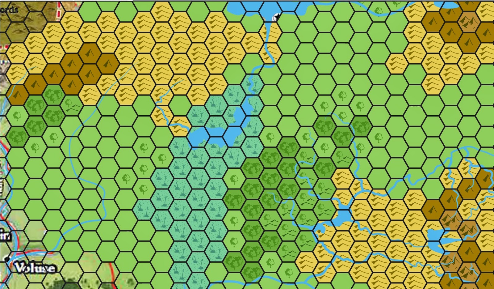
And here is a screenshot of what I've got so far...


Its the northern Stolen Lands and most of Brevoy. As you can see the hexes are re-oriented to have a northward face (the original hexes were about 19 degrees off). I did this because while the orientation worked for the AP, if we want to extend the map further we need to either re-orient the hexes or be forever bound to a left-leaning north arrow. I preferred to reorient the hexes. As I see it from a GM point of view the only real change is determining which hexes have which encounters. Aside from that, so long as you're not adapting an existing game, the change should be seamless. Existing games would have issues with kingdom boundaries and how hexes are developed.

First post - welcome!

-- Introduction --


Hello and welcome! I started this blog as a way for people to keep track of my progress on remapping the known portions of Golarion at the scale of 12 miles to a hex. This is the same scale that was used in the Kingmaker Pathfinder Adventure Path. Kingmaker may be the most popular and best example of a sandbox PnP set of adventures. It certainly is my favorite adventure path (though I'm waiting to see if the upcoming 'Iron Gods' AP displaces that). Because Kingmaker is so open ended and because there are literally innumerable ways for the plot to develop, it is impossible for Paizo to develop sufficient source material to cover every contingency.

-- Background --

One of the areas where GMs are left to their own devices in Kingmaker is in fleshing out the world around them. By this I mean not just the random encounters and commoners, but the actual world. The flora, the fauna, the geology, the hydrology. You may have a wonderful GM for your game, but he may be a sociologist by trade, or an accountant. As such, he may want to have a good handle on the world around him, but might not have the background or time to invest in fleshing it out (GM's have day jobs, too). My initial thought was to provide some of that back-filling in the form of a blog for the Kingmaker area. But I quickly realized that the world is interconnected (duh) and that to properly work out the Kingmaker area I'd have to expand beyond its borders. One thing led to another and before you know it I was contemplating remapping everything to the Kingmaker hex size.

I'm a geologist by trade and a lover of maps since I was very young. I've had a particular fondness for hex maps as my introduction to PnP roleplaying games was the Mystara campaign setting (Basic DnD). Mystara also produced a line of supplements called the Gazetteers. Each Gazetteer covered a single country within their campaign setting, much like the Pathfinder Campaign Setting does. One thing the Mystara people did that Paizo did not was to include a fold-out map with each supplement. These maps described each country at a 1 hex = 8 miles scale. I recall looking forward to the maps more than the text and being thrilled if they extended the known world by even one hex. I must not be the only one because since Mystara's demise dedicated group have kept the game alive with new supplements and new maps.